Do obsidian distribution patterns, Neolithic Çatalhöyük and the Bronze age Uluburun shipwreck have a connection?
 On the southern coast of Turkey, particularly between Bodrum in the west and Silifke in the east, there are many sheer cliffs and rocky headlands, the only gentle shore along this length being the bay between Antalya and Alanya. For much of the year the sea can be gentle and harmless, but unexpected storms can appear at any time.
The famous Uluburun and Cape Gelidonya wrecks are two of many ships that must have foundered in these waters in ancient times. These are not coasts to gamble your life with. Well, not if you don’t have good sails. And I suppose that’s what this post is about. Was there a time in the past when the more primitive, coast-hugging boats that were used then meant that the southern coasts of Turkey really were too dangerous to risk your life for?
Rough coasts have long been a problem for sailors. For example to the west, in historical ancient Greece, Corinth made its money on controlling the flow of trade along the Gulf of Corinth from those merchants that would rather avoid the sharp teeth of the southern Peloponnese.
What intrigues me is whether you can apply the same logic to the southern coast of Turkey. It’s certainly true that modern shipping has no particular fear of this coast. However, did people in the ancient past avoid it? Did they instead take a long land route to reach the Aegean or even the Black Sea?
The obvious place to head inland from the coast is the region between Silifke and Mersin. To the east of this the coast is relatively gentle, with few areas of danger. However, beyond this the coast becomes rough and treacherous.
The significance of the Uluburun shipwreck

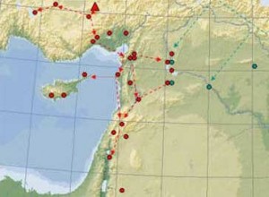
Speculative routes across Turkey during the Neolithic (red dots are sites of obsidian production, U = Uluburun, C= Cape Gelidonya)
The merchant ship now known as the Uluburun shipwreck went down off the southern Turkish coast around 1300 BC. With it went a large cargo of copper and tin ingots, amphorae of rare ointments, scrap metal and other valuable trinkets… and probably the crew. Clearly, by the time this ship went down people were not avoiding this coast.
But merchants must have been moving out into open sea slightly earlier than this. The arrival of complex sails and rigging in the Mediterranean by the beginning of the second millennium must have made it easier to steer clear of the coast with greater control. The rise of the Minoan culture (or civilisation) in Crete in the late third or early second millennium BC can be fairly confidently explained by Minoans taking control of trade in these open seas, perhaps even sailing directly south to the African coast.
By the beginning of the second millennium a major land route across Turkey was probably unnecessary. Is there any evidence that it was ever necessary?
The significance of Obsidian
At the other extreme, back in the first half of the seventh millennium BC (and possibly back to the middle of the eighth millennium BC) the distribution of Cappadocian obsidian shows an interesting pattern that might be attributable to avoiding the southern Turkish coast.
Cappadocian obsidian distribution extends west from its source into Anatolia and south to the coast around Mersin (Yümük Tepe). From there east distribution of obsidian stays close to the coast. But to the west there is no coastal distribution at all.
This strongly suggests a marine route to the Levant at this time, starting around Mersin. But it also hints that maybe sailors did not risk travelling further west.
The significance of Çatalhöyük
Maybe this is pushing things too far (probably) but Çatalhöyük also comes into being in the mid to late eighth millennium BC, at the same time as the marine obsidian route to the Levant starts. It is also in the right place for any western land route, sitting as it does in the wide open Konya Plain.
Çatalhöyük’s history extends down to around the middle of the sixth millennium BC and Çatalhöyük West extends down perhaps to around 5000 BC. It is possible that this latter date indicates a maximum final date for southern coast-avoiding land route across southern Turkey. However, Çatalhöyük West’s demise may be for other reasons.
As for any extension of the route west that is more difficult. A route may have headed north of the Turkish lake district before emerging on the Aegean coast, carrying through to the Greek mainland. Equally, a route could have extended north to the Sea of Marmara.
Either way, it is possible that an overland trade route or routes may have been a major factor in the location of places such as Mersin, Can Hasan and Çatalhöyük.


References
Sherratt, A. 2005 The Obsidian Trade in the Near East, 14,000 to 6500 BC. Arch Atlas, Feb 10, Edition 4 (this is a very fine resource)
TAY Project database (also very fine)
Picture by TimoAndDog.

{ 0 comments… add one now }